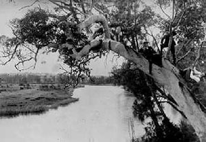
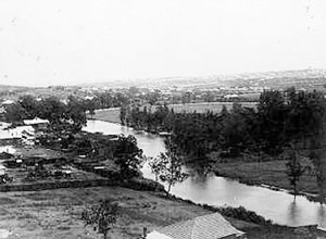
Cooks River looking up river towards Hurlstone Park.
In boater hat is Charles Smith of High Street, Canterbury.
©1918 courtesy Mr Andrews
Until 1788, the Cooks River and its environment was relatively undisturbed by man. The aboriginal population, estimated at about 1500 by Governor Phillip, lived within their tribal boundaries in the Botany Bay area by fishing, gathering shellfish, some hunting, and subsistence cropping, in a regularly shifting pattern. The bush was intermittently swept by fire, sometimes deliberately lit to clear out the undergrowth and make travel on the hunt easier: but all this did not disturb the river's ecology to any destructive extent, as the aboriginal people understood well that their survival depended on maintaining the natural vegetation and wildlife.
In 1770 Captain Cook sailed into Botany Bay, and made in his journal the fateful observation for future Australian settlement:
I found a very fine stream of fresh water on the north side in the first sandy cove within the island before which a ship might lay land-locked and wood for fuel may be got everywhere.
Cooks River looking up river towards Hurlstone Park.
In boater hat is Charles Smith of High Street, Canterbury.
©1918 courtesy Mr Andrews
Britain was thus provided with a substitute for America to which it could send its convicts. Cooks River was probably the 'fine stream', promising an adequate water supply, while the description of vegetation held the possibility of good soil on which to base a flourishing agricultural economy. However, when the white settlers at last arrived, the river and valley were rejected.
Descriptions of the country along Cooks River by the early explorers were not optimistic about the land's potential for food production. Captain John Hunter and Lieutenant Bradley both mentioned the shallowness of the water and the large swamps, in place of Cook's 'fine meadow', so it was to the alluvial terraces of the Parramatta and Hawkesbury Rivers that the farmers of the colony went. The Reverend Richard Johnson, however, took time out from his chief mission - first pastor to the settlements in New South Wales - to cultivate his properties, among them being a grant of 250 acres at Canterbury (stretching along the river from present Garnet Street, Hurlstone Park to Croydon Avenue, Ashbury). There is no evidence that he ever lived on his 'Canterbury Vale' farm. But with the help of an overseer, several convicts, and labourers paid by himself, he cleared and planted several acres.
Yields were high enough from his estates for him to be described by Watkin Tench as 'the best farmer in the colony'. When the property was sold to William Cox in 1800, it included livestock, two acres of vineyard, and another acre of orchard with orange trees, nectarines, peaches and apricots.
The original land grants bordering the river tended to be fairly large (averaging 100 acres), but very few were used for other than grazing, timber getting, and food production for individual families. Major industries of the area were fishing and lime burning, especially around the mouth of the river and in Botany Bay. In a new settlement, three basic needs had to be satisfied: the need for food, the need for water, and the need for shelter for the inhabitants. Although brick-making clay was abundant, nothing could be found for a long time to hold these bricks permanently together. Lime, essential in making mortar, was in such a short supply that most brick buildings collapsed in a heap of rubble as soon as the walls were leant on, and Governor Phillip constantly appealed for limestone to be sent out as ballast in the ships from home. Shell middens left by the aborigines on the shores of the Cooks River and Botany Bay proved to be a vital source of lime, and many colonists managed to make a living gathering the remnants from thousands of years of aboriginal meals to supply their kilns.
Casuarina trees (swamp oak and she-oak), common along the banks, also contributed to the shelter of the colony. This timber split easily to make excellent roofing shingles for both the settler's slab huts, and the brick or stone houses of the gentry, as no slate tiles were available until 1828, when Frederick Wright Unwin imported them for his city house.
The river formed a convenient natural boundary to land grants, and an effective barrier to people wishing to bring their produce to Sydney. As early as 1810, evidence of a bridge, probably at the end of Beamish Street, is found in Governor Macquarie's diary:
After resting for half an hour at Mrs Laycock's, we pursued our journey to Canterbury; thus crossing Cook's river twice over a very slender bad Bridge within two miles of Mrs Laycock's Farm and is rather dangerous for a carriage.
His only other comment was that 'the soil is bad and neither good for tillage or pasturage'.
Despite the discouragement caused by regular floods and caterpillar plagues, pressure for available land grew, as food remained so expensive in Sydney that families had to become self-sufficient in order to survive. The alluvial soil of Cooks River became attractive despite comments about its infertility, and the original grantees in many cases leased or sold their properties to people prepared to try farming in this previously unused region. After 1831, settlement along the river spread, and roads and crossings were made in several places.
Cornelius Prout built a punt to give him access to his property, Belle Ombre (along the river from today's Canterbury Road to Clissold Parade, Campsie); a punt also operated somewhere about the same time at Undercliffe, known as Thorpe's Punt. This was a link on one of the roads to the Illawarra district. Fords existed at Tempe and further up the river, but with the spread of settlement and eventually industry, permanent bridges were needed.
The Colony of New South Wales was filled with optimism through the 1830's. Government-sponsored immigration brought an enthusiastic workforce without the defeatist attitude of the convicts; merchants made large profits from these new immigrants and immediately invested the money in speculative ventures; and new companies sprang up in an economy built on taking chances. A B Spark, Leslie Duguid, and F W Unwin all built country houses beside Cooks River in the late 1830's, and by 1840, three bridge crossings were in use; Unwin's Bridge at Tempe, (to give access from Sydney to his house, Wanstead); Prout's Bridge, replacing the punt, at Canterbury; and the dam at Tempe, continuing the line of Cook's River Road (Princes Highway) past the house of Alexander Brodie Spark. His diary tells some of the story of the river:
27th June, 1838. . . The Venison we dined on on Sunday was from a fine Buck that Willie the boatman found entangled in the mud of the river. All hands were called and the Dear was secured. On returning home I found possession disputed by some men who were about carrying him off in a Cart. I quickly rescued the prize, but the animal had been so much injured that he died in the night.
5th November,1838. . . Had a conversation with the Governor on the subject of damming up Cook's River for the purpose of obtaining a constant supply of fresh water for Sydney . . .
9th November, 1838. . . Major Barney called on me afterwards in town and said that if I did not object to it the dam might be run across below the Bathing house, and the only apprehension was that my garden might be flooded. To be surrounded with the fresh water instead of salt would be highly desirable and I did not object to his proposal if he could previously ascertain that no bad consequences would follow. . .
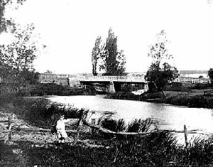
Cooks River showing Unwins Bridge, Tempe, circa 1910
In fact, Cook's River water above the dam remained brackish, and was not used as Sydney's water supply; the structure itself proved to be a menace to the river's ecology, preventing tidal flushing of deposited urban silt, and hastening ultimate logging and pollution. This was, however, a long way in the future, and Lady Franklin describes the scene at Tempe in 1840:
To the left and behind Tempe, rock rises steep, but is of most insignificant height, though styled Mt Olympus - forms a sort of small promontory, at the foot of which is a small wharf or jetty and bathing house - the intended dam begins a little higher on the opposite bank, takes a curve or bow upwards, and is to abut on this promontory - Sir G begins to think it will never be done for want of convict labour, no ships have come in for some time . . . view from Olympus of winding of river in flat bush and swamps, and see heads of Botany Bay - all ugly enough . . . garden walks at right angles crossing and Norfolk Island pines at intersections . . . orange and lemon trees . . . casuarina trees stripped of leaves with convenient branches planted in aviaries for perches of birds.
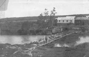
Dam and tannery at Cooks River, Canterbury, 1901
A second dam was built to serve the river's first manufacturing industry: the Australian Sugar Company's refinery at Canterbury; this location was selected because of the need for ample supplies of water in processing.
The Sugar House is placed within one hundred feet on Cook's River which is shortly expected to be fresh water, the Dam being quite close and is built of beautiful white sandstone. (Sydney Herald, 4 October, 1841)
Because industry meant workers, and workers needed amenities, the Village of Canterbury developed as a settlement with a school, a church, and, more importantly, a road from Sydney. Robert Campbell, on the Ashfield side of the river, and Cornelius Prout, on the other side, each agreed to dedicate part of his land for this road, and further, Prout promised to build a bridge using convict labour if enough money could be raised by public subscription to pay for it. The funds raised were 120 pounds short of the total cost, but the bridge was still built in 1840 on the understanding that Prout could charge the public a bridge toll until the debt to him was discharged. He was still doing this in 1853, and may have continued to do so, if an impulsive resident named John Chard had not lost his temper.
In September 1853, Cornelius Prout, injured at the unsympathetic public reaction to his continuing the charge, locked the toll gate and refused to allow anyone across. The long-suffering people of the district (who must have by now felt a certain suspicion that the debt was paid years ago) all revised their plans for travel - all but John Chard, who, having used that road for ten years saw no reason to change now, broke through the lock and went home to Kingsgrove. Prout, incensed, told the police a dramatic story about the violent nature of Chard, and even though the fine involved was only 5 pounds, had a warrant issued for his arrest. The police serving this warrant 'missed their way in the bush', having had to pass Prout's public house on the road; and appeared at midnight to get Chard out of bed, arrest him, and take him ten miles through the dark to the Watch House. After he was freed, he wrote an aggrieved letter to the Inspector General, and had his case brought up in the Legislative Council, with the result that the Government took over the Bridge and the road, removing Prout's extra source of income for ever.
The Sugar Company closed its Canterbury building in 1855, but the passing of the Act of 1848 banning noxious trades from Sydney ensured that more than enough industries of the polluting variety move to the Cooks River water supply to replace it. Wool washes, tanneries and boiling down works were established one after another from Alexandra Canal to Cup and Saucer Creek, sending their industrial waste out into a river flowing past mansions like Thomas Holt's 'The Warren' at Marrickville and Mrs Edward Campbell's 'Undercliff', still in a green and unspoiled setting. William Freame gives his memories of the scene in 1868:
On Holt's side of the river the banks were for the more part rocky, while on the other side they were alluvial . . . Nature had done much but she had been materially assisted by art. The sight of a rabbit or two scampering off now and then to their burrows gave life to the scene. Holt had erected a very picturesque little building for a Turkish bath near the river and on the opposite side of the river stood a large bathing house belonging to Campbell . . . A little further on there was a great bend in the stream, leaving on the right bank a large, horse shoe shaped flat, richly grassed and furnished here and there with a fair proportion of timber and shrubbery, which was a favourite resort of picnic parties on Sundays and holidays.
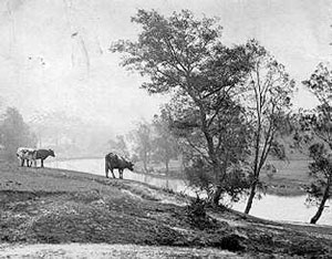
View of Cooks River from Riverview Road, Earlwood, 1904
Despite the increasingly doubtful consistency of the water, the river was a popular place in the late nineteenth century for boating, picnics and swimming, although some men took their freedom too far according to an angry gentleman from Petersham who wrote to the Herald in 1891:
Sir, - I have often heard it said that it is impossible to take ladies down to Cook's River on Saturday afternoons and holidays. Last Saturday afternoon there was abundant evidence that this is the case. From 'Starkey's Corner' to Tempe there could be counted 30 to 40 men and boys openly bathing in a perfectly nude state, some standing on projecting rocks without the slightest show of concealment. This is a state of things calling for summary treatment, and should not be allowed to continue. A few convictions would have a magical effect . . .
The 1880's in Australia were land boom years, rather like the early 1970's, and all sorts of property, suitable and unsuitable, were sold to home builders. Clearing of ground meant, faster stormwater runoff and silting of surface dust into river mudbanks. Reed beds spread wider into Cooks River, fed by this rich urban silt - causing an ominous blockage.
On the weekend of 25-27 May 1889, seventeen inches of rain fell in Sydney. All the low lying land was flooded, especially the river flats of Campsie, Canterbury and Marrickville, where the new estates were planned and built. Market gardens on the alluvial terraces were drowned, and the flimsy houses of the chinese, flattened. Late in the flood, on Monday 27, the Canterbury horse-bus set out in the morning for the city, successfully crossing the river.The Sydney Morning Herald takes up the story:
Shortly before 1 pm . . . the driver found that the volume of water had covered the bridge much more than when he left for Sydney on the morning trip. Nevertheless, he decided to try and cross the bridge. After getting some distance the four horses attached to the vehicle were swept off their feet, and the animals and vehicle were swept away with the current.
The fare boy and all four horses were drowned, the bus reduced to a heap of splintered driftwood, while the driver and passenger managed to reach safety, being dragged out of the flood by rescuers. One ended up in a tree, and the other in the remains of a Chinese garden. Notwithstanding all this tragedy: 'A man named Chard had a miraculous escape from drowning at the same spot in attempting to ford the swelling current of water'. That family did seem to have an exaggeratedly determined streak in their character.
At the height of the flood, Canterbury Road Bridge was covered by water 6 feet over the handrail, and it was 10 feet over the Sugarworks Dam. Ornamental gardens prepared for Harcourt Model Suburb were flattened, bridges over the river damaged, and people in the Tramvale Estate, Marrickville, were evacuated to higher ground. Questions were later asked about the ethics of selling such land, especially since it was settled by poorer people, labourers and artisans, who could not withstand the expense of being flooded out every few years.
The Chinese market gardeners were the real losers: in 1889 there were fifteen Chinese householders along the river bank. By 1891, there was one left.
An engineer, H B Henson, became concerned enough by the growing volume of complaints about the state of the river to put a practical mind to finding an explanation and a solution. In a paper to the engineering Association of NSW in June 1896 he made several drastic recommendations. Because the river meandered through flat land near its source, runoff streams that fed it were not swift flowing enough to carry silt out to sea. The dam and weir not only prevented tidal flushing from the bay, but also actively encouraged silt deposition. Stage one in the cleanup necessitated the removal of both obstructions; stage two, the construction of a canal and tunnel from Parramatta River via Long Cove, Ashfield, Dulwich Hill (parallel to Garnet Street) and into Cooks River. Water from swifter-flowing Sydney Harbour would thus clean up a river two miles away. Stage three, seen as ultimately necessary, would join the rivers from Homebush Bay via a canal through Strathfield to somewhere near Chullora, but this was to come later. The stage two canal would be large enough to take barge transport from the Alexandria industrial area to the Sydney docks, saving freight distances and costs considerably. Nothing was, however, done apart from some desultory attempts at dredging.
The report was not forgotten, though: in 1925 a body of citizens, formed into the Cooks River Improvement League, published a book, Our Ocean to Ocean Opportunity, designed to arouse public anger, in which they demanded that at least stage three of the canal scheme be constructed, and active efforts be made by the Government to clean up the river. Wolli Creek sewage overflow outlet was seen as the chief culprit, making the river dangerous to health; a letter from the local member of Parliament, Varney Parkes, predicted that the watercourse would become a 'miasmatic morass' within thirty years if it continued to be ignored. But it took until halfway through the depression before money was found, partly through the Unemployed Relief Council, to dredge part of the river and to begin what seemed a good idea at the time - the concreting of the banks. The Cooks River Improvement Act of 1946 established as a policy this tidying up of an undisciplined stream within neat cement boundaries with no unruly reed beds to spoil the line. It wasn't pretty, but at least it was orderly. Engineers even managed to divert completely the original river mouth to accommodate Mascot airport runways; several other minor diversions have been made over the years of suburban settlement to the natural course of the stream for reclamation or for road and bridge work.
Cooks River, Earlwood, 1900
The Cooks river of the nineteenth century was a place that landscape artists loved to paint. Conrad Martens, Samuel Elyard, Joseph Fowles, Sydney Long all have left a record of the peaceful green place that existed in their world.
The Cooks River Project Report of 1976 made recommendations that could bring this nineteenth-century harmony back again. Some need major restoration work on the environment - these are long term objectives; others are short term, easily achieved through cooperation of local bodies. A measure of compromise has been found necessary, as we are an urban people, needing services which sometimes clash with the environment; but within this framework great advances can be made. The Cooks River Valley Association has been associated as a citizens' pressure group for a great many years with the work of cleaning up the river. The building of a cycle track, tree planting and landscaping have been started, largely because of the enthusiasm of concerned people. It is only through the continuance of this involvement that the ecosystem can be restored for everyone to enjoy.
© Lesley Muir, Cooks River Festival Committee and Canterbury City Council.
Source MUIR, Lesley for the Cooks River Festival Committee. A history of Cooks River. Sydney, N.S.W.: L. Muir, [1978]
Acknowledgements | Origins
of the Barden Surname | The Earliest Bardens | The
Reasons for Migration
The First (Barden) Arrivals | The
Bounty Migrants | Down to the Beautiful Valley
Publicans, Butchers, Produce Merchants and Landholders
| A Family Business | The Barden Hotels
Items from Newspapers | Australian Men
of Mark | Sidney Barden | Joseph
Thomas Barden
Cooks River - A History
©2007 Peter Noone